Geolocate

Nantucket Island topographic map

Click on the map to display elevation.

About this map

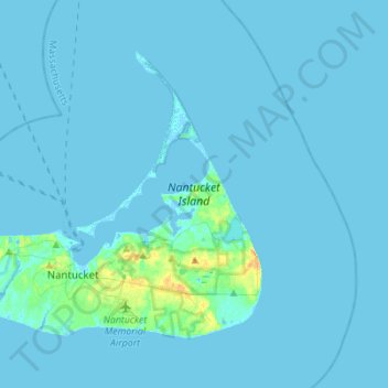
Name: Nantucket Island topographic map, elevation, terrain.

Location: Nantucket Island, Nantucket, Massachusetts, United States (41.23921 -70.23620 41.39249 -69.96043)

Average elevation: 2 m

Minimum elevation: -3 m

Maximum elevation: 28 m

Other topographic maps

Click on a map to view its topography, its elevation and its terrain.

Surfside

United States > Massachusetts > Nantucket

Average elevation: 4 m

Gear up for your next adventure:

🎒Replacement Sternum Straps - Repair parts for hiking rucksacks
🗺️Topographic Maps - Detailed maps showing elevation and terrain features
🔥Emergency Fire Starters - Reliable ignition tools for survival situations in damp conditions
Camping Shelters - Emergency and lightweight shelters for outdoor use
🩹Hiking First Aid Kits - Compact medical kits tailored for trail injuries and emergencies

As an Amazon Associate, this site earns from qualifying purchases at no extra cost to you.