
Alpirsbach topographic map
Interactive map
Click on the map to display elevation.
Alpirsbach
The township (Stadt) covers an area of 64.55 square kilometers (24.92 sq mi) of the Freudenstadt district, within the state of Baden-Württemberg and the Federal Republic of Germany. Alpirsbach is physically located in the upper Kinzig valley, in the Central Black Forest, but also in the Upper Gäu [de] at the municipal area's western extremity. The Kinzig marks the township's lowest elevation, 399 meters (1,309 ft) above sea level NN, while its highest, 800 meters (2,600 ft) NN, is in the mountainous northwest.
About this map
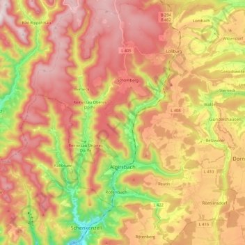
Name: Alpirsbach topographic map, elevation, terrain.
Average elevation: 649 m
Minimum elevation: 340 m
Maximum elevation: 891 m
Other topographic maps
Click on a map to view its topography, its elevation and its terrain.
Friedrichsturm
Germany > Baden-Württemberg > Landkreis Freudenstadt > Freudenstadt
Average elevation: 753 m
Bad Rippoldsau
Germany > Baden-Württemberg > Landkreis Freudenstadt > Bad Rippoldsau-Schapbach
Average elevation: 716 m