
Genesee topographic map
Interactive map
Click on the map to display elevation.
About this map
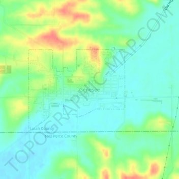
Name: Genesee topographic map, elevation, terrain.
Average elevation: 824 m
Minimum elevation: 805 m
Maximum elevation: 859 m
Genesee is located at 46°33.0′N 116°55.5′W / 46.5500°N 116.9250°W / 46.5500; -116.9250 (46.5506, -116.9245)., at an elevation of 2,680 feet (817 m) above sea level. Located in the Palouse region, it is approximately 14 miles (23 km) south of Moscow, about halfway to Lewiston. The city center is just east of US-95, and just north of the Nez Perce County line in Sections 13 and 14 of Township 37 North, Range 5 West.