Geolocate

Trosa kommun topographic map

Interactive map

Click on the map to display elevation.

About this map

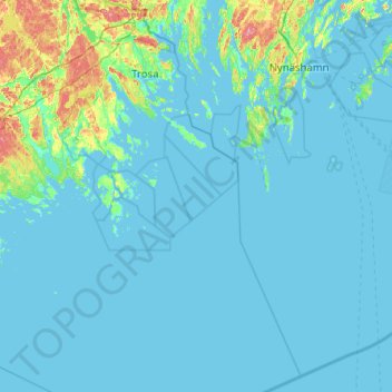
Name: Trosa kommun topographic map, elevation, terrain.

Location: Trosa kommun, Södermanland County, Sweden (58.47100 17.35600 58.99500 17.95167)

Average elevation: 10 m

Minimum elevation: -1 m

Maximum elevation: 85 m

Other topographic maps

Click on a map to view its topography, its elevation and its terrain.

Eskilstuna

Sweden > Södermanland County

Average elevation: 27 m

Strängnäs

Sweden > Södermanland County

Average elevation: 21 m

Nyköping

Sweden > Södermanland County

The small river Kilaån separates Nyköping and Arnö, with that river being even narrower. Also separating Nyköping and Arnö is the so-called Stadsfjärden (the City bay), which is a bay stretching around the Arnö peninsula down to the neighboring municipality of Oxelösund. Stadsfjärden is primarily used…

Average elevation: 25 m

Eskilstuna

Sweden > Södermanland County

Average elevation: 27 m

Lacka

Sweden > Södermanland County

Average elevation: 1 m

Fogdö

Sweden > Södermanland County

Average elevation: 12 m

Källslätten

Sweden > Södermanland County > Mariefred

Average elevation: 31 m

Strängnäs

Sweden > Södermanland County

Average elevation: 21 m

Riby

Sweden > Södermanland County

Average elevation: 24 m

Kjulaås

Sweden > Södermanland County

Average elevation: 17 m

Katrineholm

Sweden > Södermanland County

Average elevation: 47 m

Djupvik

Sweden > Södermanland County

Average elevation: 65 m

Flen

Sweden > Södermanland County > Flen

Average elevation: 44 m