
Winterthur topographic map
Interactive map
Click on the map to display elevation.
About this map
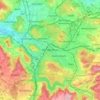
Name: Winterthur topographic map, elevation, terrain.
Location: Winterthur, Bezirk Winterthur, Zurich, Switzerland (47.44972 8.65661 47.54800 8.80994)
Average elevation: 504 m
Minimum elevation: 390 m
Maximum elevation: 696 m
Winterthur is located at an elevation of 439 meters (1,440 ft). The city is located in a basin south and east of the river Töss before it meets the High Rhine after 10 kilometers. The Eulach, a small river, flows from the town's east end through the middle of the town to meet the Töss at the west exit of the city. Because of this the town is colloquially also called "Eulachstadt". Zürich lies about 20 km (12 mi) southwest of Winterthur.
Other topographic maps
Click on a map to view its topography, its elevation and its terrain.
Ellikerbach
Switzerland > Zurich > Bezirk Winterthur > Ellikon an der Thur
Ellikerbach, Untergris, Ellikon an der Thur, Bezirk Winterthur, Zurich, 8548, Switzerland
Average elevation: 400 m