
Upplands Väsby kommun topographic map
Interactive map
Click on the map to display elevation.
About this map
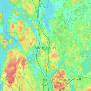
Name: Upplands Väsby kommun topographic map, elevation, terrain.
Location: Upplands Väsby kommun, Stockholm County, Sweden (59.45732 17.79932 59.58215 18.04414)
Average elevation: 20 m
Minimum elevation: -7 m
Maximum elevation: 68 m
Other topographic maps
Click on a map to view its topography, its elevation and its terrain.
Södertälje
Prior to 600 AD, the lake Mälaren was connected to the sea. Due to land elevation, the lake was slowly cut off, and boats had to be dragged over land to and from the lake. This demanded labour, who settled in a village here.
Average elevation: 38 m