
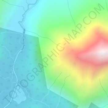
Waterton-Glacier International Peace Park topographic map
Interactive map
Click on the map to display elevation.
About this map
Name: Waterton-Glacier International Peace Park topographic map, elevation, terrain.
Average elevation: 1,481 m
Minimum elevation: 1,036 m
Maximum elevation: 2,631 m
Other topographic maps
Click on a map to view its topography, its elevation and its terrain.
Yellowstone River
United States of America > Montana
Yellowstone River, Custer County, Montana, 59301, United States of America
Average elevation: 720 m
Gardiner
United States of America > Montana > Gardiner
Gardiner, Park County, Montana, United States of America
Average elevation: 1,931 m
Belgrade
United States of America > Montana > Belgrade
Belgrade, Gallatin County, Montana, 59714, United States of America
Average elevation: 1,355 m
Snowden
United States of America > Montana > Snowden
Snowden, Roosevelt County, Montana, United States of America
Average elevation: 597 m
Belt Butte
United States of America > Montana
Belt Butte, Cascade County, Montana, United States of America
Average elevation: 1,202 m
McCone County
United States of America > Montana
McCone County, Montana, United States of America
Average elevation: 761 m
West Glacier
United States of America > Montana > West Glacier
West Glacier, Flathead County, Montana, 59936, United States of America
Average elevation: 1,201 m
Creston
United States of America > Montana > Creston
Creston, Flathead County, Montana, 59904, United States of America
Average elevation: 897 m
Mount Vernon
United States of America > Montana
Mount Vernon, Lincoln County, Montana, United States of America
Average elevation: 1,460 m
Saltese
United States of America > Montana > Saltese
Saltese, Mineral County, Montana, United States of America
Average elevation: 1,259 m
Hirsch
United States of America > Montana > Hirsch
Hirsch, Lockwood, Yellowstone County, Montana, United States of America
Average elevation: 959 m