
Krakow topographic map
Interactive map
Click on the map to display elevation.
About this map
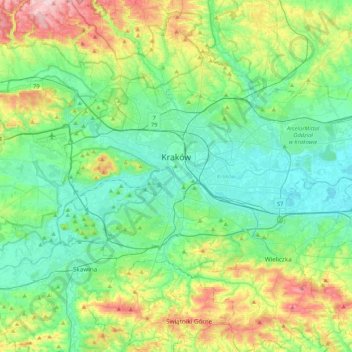
Name: Krakow topographic map, elevation, terrain.
Location: Krakow, Lesser Poland Voivodeship, Poland (49.96767 19.79224 50.12613 20.21735)
Average elevation: 263 m
Minimum elevation: 189 m
Maximum elevation: 469 m
Other topographic maps
Click on a map to view its topography, its elevation and its terrain.
966
Poland > Lesser Poland Voivodeship > Wieliczka County > Lednica Górna > Świdówka
Average elevation: 355 m
Czarny Staw Polski
Poland > Lesser Poland Voivodeship > Tatra County > Brzegi
Average elevation: 1,810 m
Podkościele
Poland > Lesser Poland Voivodeship > Tarnów County > Poręba Radlna
Average elevation: 267 m
Rysy
Poland > Lesser Poland Voivodeship > Tatra County > Brzegi
It is possible to reach the peak from the Slovak side, starting at Štrbské pleso and passing Chata pod Rysmi, a mountain chalet at an altitude of 2,250 m (7,380 ft). Between November 1 and June 15, the trail and chalet on the Slovak side are closed.
Average elevation: 2,005 m
Rzeszotary Górne
Poland > Lesser Poland Voivodeship > Kraków County > Rzeszotary
Average elevation: 332 m
Podzamcze
Poland > Lesser Poland Voivodeship > Kraków County > Korzkiew > Podzamcze
Average elevation: 321 m
Stasindowie
Poland > Lesser Poland Voivodeship > Tatra County > Gliczarów Górny
Average elevation: 894 m
Obidowa
Poland > Lesser Poland Voivodeship > Nowy Targ County
The summit of Turbacz has a subarctic climate (Köppen Dfc) due to its elevation. The average temperatures are comparable with those found in places in far Northern Europe, such as Alta, Norway, however, the high annual precipitation in combination with the low temperatures places it firmly within the…
Average elevation: 1,117 m
Tatry
Poland > Lesser Poland Voivodeship > Tatra County > Zakopane
The Tatras lie in the temperate zone of Central Europe. They are an important barrier to the movements of air masses. Their mountainous topography causes one of the most diverse climates in that region.
Average elevation: 1,647 m
Grzechynia Dolna
Poland > Lesser Poland Voivodeship > Sucha County > Grzechynia
Average elevation: 452 m
Dwudniaki
Poland > Lesser Poland Voivodeship > Tarnów County > Wierzchosławice
Average elevation: 192 m
Morskie Oko
Poland > Lesser Poland Voivodeship > Tatra County > Brzegi
Morskie Oko at the foothill of Tatra Mountains in southern Poland which average 2,000 metres (6,600 ft) in elevation
Average elevation: 1,749 m
Kaniówka
Poland > Lesser Poland Voivodeship > Tatra County > Białka Tatrzańska
Average elevation: 794 m
Babia Góra / Babia hora
Poland > Lesser Poland Voivodeship > Sucha County > Zawoja
Gentle from the south, steep from the north, Babia Góra is home to bear, lynx, wolf and other species; as well as alpine flora endemic at this altitude. The first attempts to protect the area were made in the 1930s. In 1933 the Nature Reserve of Babia Góra was established on the Polish side. Later, in 1954,…
Average elevation: 1,395 m
Wielki Giewont
Poland > Lesser Poland Voivodeship > Tatra County > Zakopane
Average elevation: 1,478 m
Myślenice
Poland > Lesser Poland Voivodeship > Myślenice County > Myślenice > Myślenice
Average elevation: 374 m
Pieniny
Poland > Lesser Poland Voivodeship > Nowy Targ County > Sromowce Niżne
Average elevation: 632 m
Czułówek
Poland > Lesser Poland Voivodeship > Kraków County > Czułówek > Czułówek
Average elevation: 264 m