
Ponte Vedra Beach topographic map
Interactive map
Click on the map to display elevation.
About this map
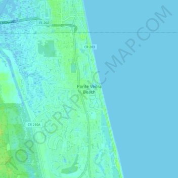
Name: Ponte Vedra Beach topographic map, elevation, terrain.
Average elevation: 2 m
Minimum elevation: -3 m
Maximum elevation: 11 m
Other topographic maps
Click on a map to view its topography, its elevation and its terrain.
Palm Valley
United States > Florida > Saint Johns County > Ponte Vedra Beach
Palm Valley, Ponte Vedra Beach, Saint Johns County, Florida, United States
Average elevation: 4 m
Ponte Vedra Beach
United States > Florida > Saint Johns County > Ponte Vedra Beach
Ponte Vedra Beach, Saint Johns County, Florida, 32250, United States
Average elevation: 3 m