
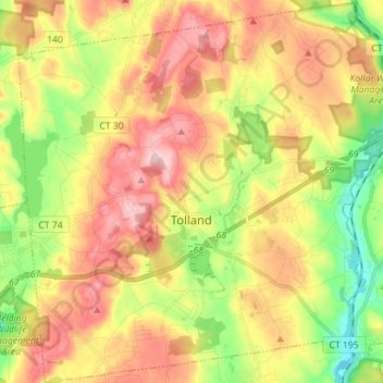
Tolland topographic map
Interactive map
Click on the map to display elevation.
About this map
Name: Tolland topographic map, elevation, terrain.
Average elevation: 201 m
Minimum elevation: 94 m
Maximum elevation: 308 m
Tolland's climate is classified as warm summer continental (Dfb), as is typical of the eastern hills of Connecticut. The area enjoys some characteristics hot-summer continental climate (Dfa) due to a relatively high July mean temperature of 70.7 °F (21.5 °C), which is very close to the threshold of 71.6 °F (22 °C) mean temperature required for a hot-summer climate. The area experiences four distinct seasons, with cold, snowy winters and warm to hot summers. The climate of Tolland is distinguished from the warmer climate of nearby Hartford, CT, due to its elevation. The area is prone to blizzards and ice storms in the winter, and during the summer it occasionally experiences tropical activity (though less severe than in lower elevations of the state). Precipitation is distributed fairly evenly throughout the year, with the wettest month being November and the driest being February.
Other topographic maps
Click on a map to view its topography, its elevation and its terrain.
Blue Hills
United States > Capitol Planning Region > Bloomfield
Blue Hills, Bloomfield, Capitol Planning Region, United States
Average elevation: 31 m
City of New Britain Public Watershed Lands
United States > Capitol Planning Region > New Britain
City of New Britain Public Watershed Lands, Roslyn Drive, New Britain, Capitol Planning Region, 06052, United States
Average elevation: 102 m