
Invercargill City topographic map
Interactive map
Click on the map to display elevation.
About this map
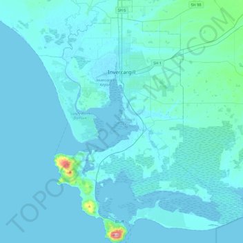
Name: Invercargill City topographic map, elevation, terrain.
Location: Invercargill City, Southland, New Zealand (-46.62559 168.19540 -46.32217 168.54278)
Average elevation: 11 m
Minimum elevation: -2 m
Maximum elevation: 245 m
Other topographic maps
Click on a map to view its topography, its elevation and its terrain.
Tuatapere Te Waewae Community
New Zealand > Southland > Southland District
Tuatapere Te Waewae Community, Southland District, Southland, 9620, New Zealand
Average elevation: 324 m
Greenhills
New Zealand > Southland > Invercargill City
Greenhills, Invercargill City, Southland, New Zealand
Average elevation: 10 m
Borland
New Zealand > Southland > Southland District > Fiordland Community
Borland, Fiordland Community, Southland District, Southland, New Zealand
Average elevation: 880 m
Merrivale
New Zealand > Southland > Southland District > Tuatapere Te Waewae Community
Merrivale, Tuatapere Te Waewae Community, Southland District, Southland, New Zealand
Average elevation: 192 m
Fiordland Community
New Zealand > Southland > Southland District
Fiordland Community, Southland District, Southland, New Zealand
Average elevation: 525 m
Fern Hill
New Zealand > Southland > Southland District > Fiordland Community
Fern Hill, Fiordland Community, Southland District, Southland, New Zealand
Average elevation: 259 m
Lake Te Anau
New Zealand > Southland > Southland District
Lake Te Anau, Southland District, Southland, New Zealand
Average elevation: 683 m
Sutherland Falls
New Zealand > Southland > Southland District > Fiordland Community
Sutherland Falls, Fiordland Community, Southland District, Southland, New Zealand
Average elevation: 1,006 m
Sutherland Sound
Sutherland Sound, Southland, New Zealand
Average elevation: 530 m
Mount Owen
New Zealand > Southland > Southland District > Fiordland Community
Mount Owen, Fiordland Community, Southland District, Southland, New Zealand
Average elevation: 1,269 m
Milford Sound
New Zealand > Southland > Southland District > Fiordland Community
Milford Sound, Fiordland Community, Southland District, Southland, New Zealand
Average elevation: 655 m
The Downs
New Zealand > Southland > Southland District > Tuatapere Te Waewae Community
The Downs, Tuatapere Te Waewae Community, Southland District, Southland, New Zealand
Average elevation: 34 m
Turner Falls
New Zealand > Southland > Southland District > Fiordland Community
Turner Falls, Fiordland Community, Southland District, Southland, New Zealand
Average elevation: 1,335 m
352
New Zealand > Southland > Southland District > Fiordland Community
352, Fiordland Community, Southland District, Southland, New Zealand
Average elevation: 273 m
Mount Makere
New Zealand > Southland > Southland District > Fiordland Community
Mount Makere, Fiordland Community, Southland District, Southland, New Zealand
Average elevation: 1,433 m
Mount Lyall
New Zealand > Southland > Southland District
Mount Lyall, Southland District, Southland, New Zealand
Average elevation: 575 m
Long Burn
New Zealand > Southland > Southland District > Fiordland Community
Long Burn, Fiordland Community, Southland District, Southland, New Zealand
Average elevation: 721 m
White Peak
New Zealand > Southland > Southland District > Tuatapere Te Waewae Community
White Peak, Tuatapere Te Waewae Community, Southland District, Southland, New Zealand
Average elevation: 1,153 m
Dipton
New Zealand > Southland > Southland District > Oreti Community > Dipton
Dipton, Oreti Community, Southland District, Southland, 9791, New Zealand
Average elevation: 159 m
Waikawa
New Zealand > Southland > Southland District > Waihopai Toetoe Community > Waikawa
Waikawa, Waihopai Toetoe Community, Southland District, Southland, 9884, New Zealand
Average elevation: 39 m
Jamestown
New Zealand > Southland > Southland District > Fiordland Community
Jamestown, Fiordland Community, Southland District, Southland, New Zealand
Average elevation: 43 m
Blackmount
New Zealand > Southland > Southland District > Tuatapere Te Waewae Community > Blackmount
Blackmount, Tuatapere Te Waewae Community, Southland District, Southland, New Zealand
Average elevation: 170 m
Mitre Peak
New Zealand > Southland > Southland District > Fiordland Community
Mitre Peak, Fiordland Community, Southland District, Southland, New Zealand
Average elevation: 657 m
Milford Sound
New Zealand > Southland > Southland District > Fiordland Community > Milford Sound
Milford Sound, Fiordland Community, Southland District, Southland, New Zealand
Average elevation: 304 m
Depth Peak
New Zealand > Southland > Southland District > Fiordland Community
Depth Peak, Fiordland Community, Southland District, Southland, New Zealand
Average elevation: 680 m
Invercargill
New Zealand > Southland > Invercargill City > Invercargill
Invercargill, Invercargill City, Southland, 9810, New Zealand
Average elevation: 16 m