
Ashland County topographic map
Interactive map
Click on the map to display elevation.
About this map
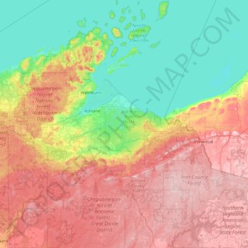
Name: Ashland County topographic map, elevation, terrain.
Location: Ashland County, Wisconsin, United States of America (45.98103 -90.92748 47.08074 -90.30000)
Average elevation: 324 m
Minimum elevation: 174 m
Maximum elevation: 569 m
Other topographic maps
Click on a map to view its topography, its elevation and its terrain.
Burkhardt
United States of America > Wisconsin > Town of Saint Joseph > Burkhardt
Average elevation: 273 m