Geolocate

Catanduanes Island topographic map

Interactive map

Click on the map to display elevation.

About this map

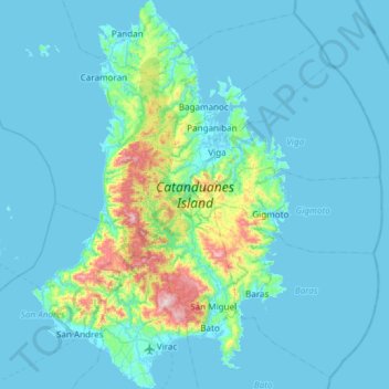
Name: Catanduanes Island topographic map, elevation, terrain.

Location: Catanduanes Island, Catanduanes, Bicol Region, Philippines (13.51666 124.02361 14.09864 124.42182)

Average elevation: 73 m

Minimum elevation: -2 m

Maximum elevation: 797 m

Other topographic maps

Click on a map to view its topography, its elevation and its terrain.

Paniquihan

Philippines > Catanduanes > Baras

Average elevation: 77 m

Virac

Philippines > Catanduanes

Average elevation: 95 m

Paraiso

Philippines > Catanduanes

Average elevation: 200 m

Panay Island

Philippines > Catanduanes > Quigaray

Average elevation: 15 m

Sapang Palay

Philippines > Catanduanes > Sapang Palay

Average elevation: 28 m

Boton

Philippines > Catanduanes > Boton

Average elevation: 141 m

Buhi

Philippines > Catanduanes > Buhi

Average elevation: 159 m