
Bazaruto topographic map
Interactive map
Click on the map to display elevation.
About this map
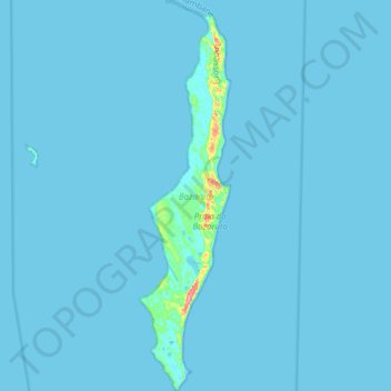
Name: Bazaruto topographic map, elevation, terrain.
Location: Bazaruto, Inhassoro, Inhambane, Mozambique (-21.79414 35.42509 -21.50351 35.49730)
Average elevation: 2 m
Minimum elevation: -3 m
Maximum elevation: 108 m
The warm, southward-flowing Mozambique Current seems to contribute to the increasing buildup of the sandy coastline. Because the water along this coastal area is very clear, much of the sub-surface channel pattern around the island is discernible. Several narrow lines of plankton bloom parallel the shoreline on the satellite photo below. Bazaruto Archipelago holds the largest population of dugong in Mozambique (around 300 animals) and almost certainly is the last remaining viable population of dugongs left off East Africa. The coastal plains show numerous lakes and a swampy environment that appears to be karst topography. Underlying the area is limestone rock that has eroded into a pockmarked landscape, creating water-filled sinkholes. Rainfall in this humid tropical climate amounts to around 850 mm (33 inches) annually, largely concentrated in the months December to March.