
Renukut topographic map
Interactive map
Click on the map to display elevation.
About this map
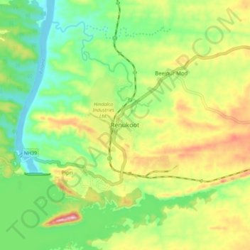
Name: Renukut topographic map, elevation, terrain.
Average elevation: 285 m
Minimum elevation: 194 m
Maximum elevation: 423 m
Renukoot is located at 24°12′N 83°02′E / 24.2°N 83.03°E / 24.2; 83.03. It has an average elevation of 283 metres (931 feet). Renukoot lies in the southeast-most part of Uttar Pradesh and sits next to Shakti Nagar, Anpara, ((Dalla)) and Obra. Renukoot is in Sonebhadra district which is the only district in India which borders four states, namely Madhya Pradesh, Chhattisgarh, Jharkhand, and Bihar.