
Uhuru Park topographic map
Interactive map
Click on the map to display elevation.
About this map
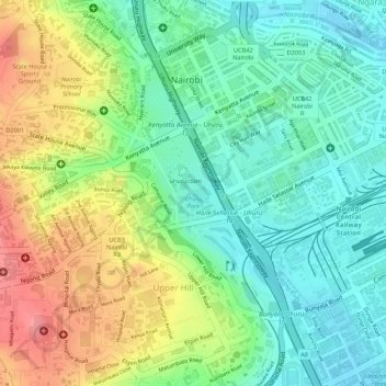
Name: Uhuru Park topographic map, elevation, terrain.
Location: Uhuru Park, UpperHill, Nairobi, Kenya (-1.29331 36.81451 -1.28912 36.82004)
Average elevation: 1,685 m
Minimum elevation: 1,649 m
Maximum elevation: 1,737 m
Other topographic maps
Click on a map to view its topography, its elevation and its terrain.
Nairobi River
Nairobi River, Nairobi, P. O. BOX 66831, Kenya
Average elevation: 1,763 m
Central Park
Central Park, Upper Hill, Nairobi, Kenya
Average elevation: 1,687 m