
Gatwekera topographic map
Interactive map
Click on the map to display elevation.
About this map
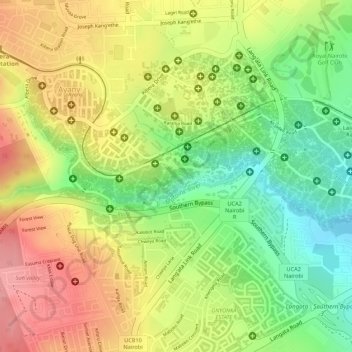
Name: Gatwekera topographic map, elevation, terrain.
Location: Gatwekera, Nairobi, Kenya (-1.31763 36.77844 -1.31327 36.78869)
Average elevation: 1,744 m
Minimum elevation: 1,681 m
Maximum elevation: 1,800 m
Other topographic maps
Click on a map to view its topography, its elevation and its terrain.
Nairobi River
Nairobi River, Nairobi, P. O. BOX 66831, Kenya
Average elevation: 1,763 m
Central Park
Central Park, Upper Hill, Nairobi, Kenya
Average elevation: 1,687 m