
Hallandsåsen topographic map
Interactive map
Click on the map to display elevation.
About this map
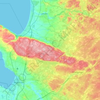
Name: Hallandsåsen topographic map, elevation, terrain.
Location: Hallandsåsen, Skåne County, 286 92, Sweden (56.27828 12.73821 56.46228 13.44829)
Average elevation: 71 m
Minimum elevation: -1 m
Maximum elevation: 222 m
Other topographic maps
Click on a map to view its topography, its elevation and its terrain.
Skövde
Sweden > Västra Götaland County
Skövde has a maritime-continental hybrid climate. The town is influenced by being in the slope of a hill, which leads to warmer overnight lows than in Skara on the western side of the same higher area. In July 2018, Skövde recorded a 22 °C (72 °F) mean during the 2018 European heat wave. This makes it one…
Average elevation: 181 m
Uppsala
Situated on the fertile Uppsala flatlands of muddy soil, the city features the small Fyris River (Fyrisån) flowing through the landscape surrounded by lush vegetation. Parallel to the river runs the glacial ridge of Uppsalaåsen at an elevation around 30 m (98 ft), the site of Uppsala's castle, from which…
Average elevation: 29 m
Ven
Sweden > Skåne County > Tuna
Along the entire coast, the island drops steeply towards the sea where the Öresund meets a rocky beach. This steep coast is called Backafall. Ven's backafall is a nature reserve established in 1990. There are no large forests, but smaller stands of trees occur closest to the coast the slightly higher…
Average elevation: 13 m
Abisko
Permafrost is common around the village albeit this low altitude permafrost is disappearing because of global warming and increased snowfall.
Average elevation: 395 m
Jönköping
Jönköping's climate was humid continental (Köppen Dfb) with long, cold winters and short, warm summers during the 1961–1990 period. However, the window between subarctic and oceanic is very small in this marine-influenced climate type, and in recent years the climate has more resembled very cold oceanic.…
Average elevation: 215 m
Uppsala
Situated on the fertile Uppsala flatlands of muddy soil, the city features the small Fyris River (Fyrisån) flowing through the landscape surrounded by lush vegetation. Parallel to the river runs the glacial ridge of Uppsalaåsen at an elevation around 30 m (98 ft), the site of Uppsala's castle, from which…
Average elevation: 29 m