
Snowmass topographic map
Interactive map
Click on the map to display elevation.
About this map
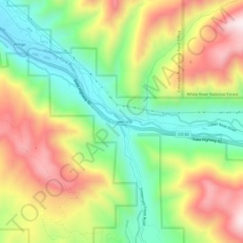
Name: Snowmass topographic map, elevation, terrain.
Location: Snowmass, Pitkin County, Colorado, 81654, United States (39.31165 -107.00616 39.35165 -106.96616)
Average elevation: 2,322 m
Minimum elevation: 2,055 m
Maximum elevation: 2,659 m
Other topographic maps
Click on a map to view its topography, its elevation and its terrain.
Aspen
United States > Colorado > Pitkin County
Aspen is a home rule municipality that is the county seat and the most populous municipality of Pitkin County, Colorado, United States. The city population was 7,004 at the 2020 United States Census. Aspen is in a remote area of the Rocky Mountains' Sawatch Range and Elk Mountains, along the Roaring Fork River…
Average elevation: 2,568 m
Aspen
United States > Colorado > Pitkin County
Aspen is the home rule city that is the county seat and the most populous municipality of Pitkin County, Colorado, United States. The city population was 7,004 at the 2020 United States census. Aspen is in a remote area of the Rocky Mountains' Sawatch Range and Elk Mountains, along the Roaring Fork River at an…
Average elevation: 2,568 m
Aspen
United States > Colorado > Pitkin County
Aspen is a home rule municipality that is the county seat and the most populous municipality of Pitkin County, Colorado, United States. The city population was 7,004 at the 2020 United States Census. Aspen is in a remote area of the Rocky Mountains' Sawatch Range and Elk Mountains, along the Roaring Fork River…
Average elevation: 2,568 m