
Ilhabela topographic map
Interactive map
Click on the map to display elevation.
Ilhabela
Throughout the 19th century, activities concerning sugarcane began to decay, but they were soon replaced by coffee, following a trend seen around the rest of the Paraíba Valley. Production concentrated in Ponta do Boi, in the south part of the island, more precisely at Nossa Senhora das Galhetas, Figueira e Sombrio Farm. Growing coffee resulted in an even more intense deforestation than that caused by sugarcane, and the plants could be cultivated in altitudes higher than 500 meters, by the main island's escarpments.
About this map
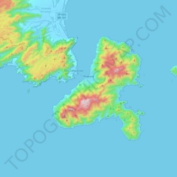
Name: Ilhabela topographic map, elevation, terrain.
Average elevation: 116 m
Minimum elevation: -4 m
Maximum elevation: 1,328 m
Other topographic maps
Click on a map to view its topography, its elevation and its terrain.
Ilha Sumítica
Brazil > São Paulo > Região Metropolitana do Vale do Paraíba e Litoral Norte > Ilhabela
Average elevation: 1 m
Ilha Sumítica
Brazil > São Paulo > Região Metropolitana do Vale do Paraíba e Litoral Norte > Ilhabela
Average elevation: 1 m
Paiol Grande
Brazil > São Paulo > Região Metropolitana do Vale do Paraíba e Litoral Norte > São Bento do Sapucaí
Average elevation: 1,339 m
Rio Paraíba do Sul
Brazil > São Paulo > Região Metropolitana do Vale do Paraíba e Litoral Norte > Guaratinguetá
Average elevation: 546 m
São José dos Campos
Brazil > São Paulo > Região Metropolitana do Vale do Paraíba e Litoral Norte
In the urban area, there are rolling plateaus and hills. The lowest elevation in the city (and also in the municipality) is found in the Paraíba do Sul River, at a mean elevation of 550 m.
Average elevation: 634 m