
Kimhwa County topographic map
Interactive map
Click on the map to display elevation.
About this map
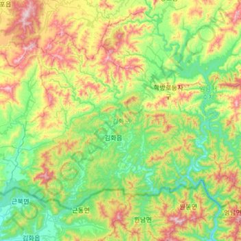
Name: Kimhwa County topographic map, elevation, terrain.
Location: Kimhwa County, Kangwon-do, North Korea (38.30111 127.36290 38.59454 127.87477)
Average elevation: 478 m
Minimum elevation: 177 m
Maximum elevation: 1,150 m
Other topographic maps
Click on a map to view its topography, its elevation and its terrain.
Triangle Hill
Triangle Hill, Kimhwa County, Kangwon-do, North Korea
Average elevation: 391 m
Imnam Dam
Imnam Dam, Kimhwa County, Kangwon-do, North Korea
Average elevation: 295 m