
Rohrbach-lès-Bitche topographic map
Interactive map
Click on the map to display elevation.
About this map
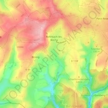
Name: Rohrbach-lès-Bitche topographic map, elevation, terrain.
Average elevation: 325 m
Minimum elevation: 252 m
Maximum elevation: 386 m
Located in the open country, at an elevation of around 260 metres, the village is dominated to the west by the 360-metre-tall Guckenberg, the last hill of the Lorraine plateau. It is one of the earliest villages of the Pays de Bitche. The Vosges pink sandstone appears on the outskirts of the commune, but is mostly covered by forest.
Other topographic maps
Click on a map to view its topography, its elevation and its terrain.
Walschbronn
Walschbronn, Sarreguemines, Moselle, Grand Est, Metropolitan France, 57720, France
Average elevation: 328 m
57230
France > Grand Est > Moselle > Éguelshardt
57230, Éguelshardt, Sarreguemines, Moselle, Grand Est, Metropolitan France, France
Average elevation: 307 m
Vic-sur-Seille
Vic-sur-Seille, Sarrebourg-Château-Salins, Moselle, Grand Est, Metropolitan France, 57630, France
Average elevation: 240 m
Mont Saint-Quentin
France > Grand Est > Moselle > Scy-Chazelles
Mont Saint-Quentin, Scy-Chazelles, Metz, Moselle, Grand Est, Metropolitan France, 57160, France
Average elevation: 237 m
Craincourt
Craincourt, Sarrebourg-Château-Salins, Moselle, Grand Est, Metropolitan France, 57590, France
Average elevation: 219 m
Longeville-lès-Saint-Avold
Longeville-lès-Saint-Avold, Forbach-Boulay-Moselle, Moselle, Grand Est, Metropolitan France, 57740, France
Average elevation: 304 m
Henriville
Henriville, Forbach-Boulay-Moselle, Moselle, Grand Est, Metropolitan France, 57450, France
Average elevation: 281 m
Creutzwald
Creutzwald, Forbach-Boulay-Moselle, Moselle, Grand Est, Metropolitan France, 57150, France
Average elevation: 237 m
Gravelotte
Gravelotte, Metz, Moselle, Grand Est, Metropolitan France, 57130, France
Average elevation: 301 m
Serémange-Erzange
Serémange-Erzange, Thionville, Moselle, Grand Est, Metropolitan France, 57290, France
Average elevation: 209 m
Cité Émile Huchet
France > Grand Est > Moselle > Saint-Avold
Cité Émile Huchet, Saint-Avold, Forbach-Boulay-Moselle, Moselle, Grand Est, Metropolitan France, 57500, France
Average elevation: 253 m
Montigny-lès-Metz
Montigny-lès-Metz, Metz, Moselle, Grand Est, Metropolitan France, 57950, France
Average elevation: 179 m
Berg-sur-Moselle
Berg-sur-Moselle, Thionville, Moselle, Grand Est, Metropolitan France, 57570, France
Average elevation: 168 m
Mattel
France > Grand Est > Moselle > Sarrebourg
Mattel, Hoff, Sarrebourg, Sarrebourg-Château-Salins, Moselle, Grand Est, Metropolitan France, 57400, France
Average elevation: 269 m
Hannocourt
France > Grand Est > Moselle > Hannocourt
Hannocourt, Sarrebourg-Château-Salins, Moselle, Grand Est, Metropolitan France, 57590, France
Average elevation: 257 m
Saint-Quirin
France > Grand Est > Moselle > Saint-Quirin
Saint-Quirin, Sarrebourg-Château-Salins, Moselle, Grand Est, Metropolitan France, 57560, France
Average elevation: 432 m
Audun-le-Tiche
France > Grand Est > Moselle > Audun-le-Tiche
Audun-le-Tiche, Thionville, Moselle, Grand Est, Metropolitan France, 57390, France
Average elevation: 383 m
Everst Garten
France > Grand Est > Moselle > Villing > Trois Maisons
Everst Garten, Trois Maisons, Villing, Forbach-Boulay-Moselle, Moselle, Grand Est, Metropolitan France, 57550, France
Average elevation: 286 m