Geolocate

Yarra Ranges National Park topographic map

Interactive map

Click on the map to display elevation.

About this map

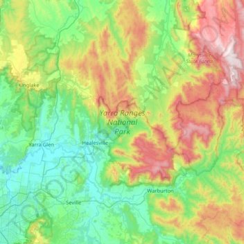
Name: Yarra Ranges National Park topographic map, elevation, terrain.

Location: Yarra Ranges National Park, Reefton, Melbourne, Shire of Yarra Ranges, Victoria, Australia (-37.79254 145.52154 -37.42736 146.16441)

Average elevation: 465 m

Minimum elevation: 53 m

Maximum elevation: 1,459 m

Other topographic maps

Click on a map to view its topography, its elevation and its terrain.

Northgateway Reserve

Australia > Victoria > Melbourne

Average elevation: 72 m

Melbourne

Australia > Victoria > Melbourne

Melbourne is also prone to isolated convective showers forming when a cold pool crosses the state, especially if there is considerable daytime heating. These showers are often heavy and can include hail, squalls, and significant drops in temperature, but they often pass through very quickly with a rapid…

Average elevation: 49 m

Koomba Park

Australia > Victoria > Melbourne

Average elevation: 96 m

Brimbank Park

Australia > Victoria > Melbourne

Average elevation: 52 m

Silvan Reservoir

Australia > Victoria > Melbourne

Average elevation: 270 m

Melbourne Water Reserve

Australia > Victoria > Melbourne

Average elevation: 127 m

Lincoln Square

Australia > Victoria > Melbourne > Carlton

Average elevation: 37 m

Maroondah Aquaduct

Australia > Victoria > Melbourne

Average elevation: 96 m

Navan Islan 3

Australia > Victoria > Melbourne

Average elevation: 154 m

Banksia Park

Australia > Victoria > Melbourne

Average elevation: 34 m

Brighton East

Australia > Victoria > Melbourne > Brighton East

Average elevation: 25 m

Maroondah Aquaduct

Australia > Victoria > Melbourne

Average elevation: 101 m

Mothers Beach

Australia > Victoria > Melbourne

Average elevation: 9 m

Montrose

Australia > Victoria > Melbourne > Montrose

Average elevation: 211 m

Hawthorn East

Australia > Victoria > Melbourne > Hawthorn East

Average elevation: 50 m

Brunswick East

Australia > Victoria > Melbourne > Brunswick East

Average elevation: 45 m

Yering

Australia > Victoria > Melbourne > Yering

Average elevation: 93 m

Keysborough

Australia > Victoria > Melbourne > Keysborough

Average elevation: 18 m

Clyde North

Australia > Victoria > Melbourne > Clyde North

Average elevation: 38 m

Chadstone

Australia > Victoria > Melbourne > Chadstone

Average elevation: 71 m

Cockatoo

Australia > Victoria > Melbourne > Cockatoo

Average elevation: 236 m

Burwood East

Australia > Victoria > Melbourne > Burwood East

Average elevation: 103 m