
Hassan topographic map
Interactive map
Click on the map to display elevation.
About this map
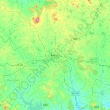
Name: Hassan topographic map, elevation, terrain.
Average elevation: 949 m
Minimum elevation: 847 m
Maximum elevation: 1,275 m
Other topographic maps
Click on a map to view its topography, its elevation and its terrain.
KR Puram local Park
India > Karnataka > Hasana taluk > Hassan
KR Puram local Park, Ravindra Nagar, K R Puram, Hassan, Hasana taluk, Hassan district, Karnataka, 573201, India
Average elevation: 950 m