
Bawtry topographic map
Interactive map
Click on the map to display elevation.
Bawtry
The town's former prosperity was based on communications: the River Idle when it was a port, the Great North Road in the coaching era, and the Great Northern Railway. Its geographical location is 53° 25' 40" North, 1° 1' West, at an elevation of some 65 feet (20 m) above sea level.
About this map
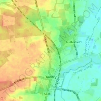
Name: Bawtry topographic map, elevation, terrain.
Location: Bawtry, Doncaster, South Yorkshire, England, United Kingdom (53.42449 -1.06824 53.45713 -1.00676)
Average elevation: 19 m
Minimum elevation: 0 m
Maximum elevation: 39 m
England trails, hiking, mountain biking, running and outdoor activities
Other topographic maps
Click on a map to view its topography, its elevation and its terrain.