
Aizawl topographic map
Interactive map
Click on the map to display elevation.
About this map
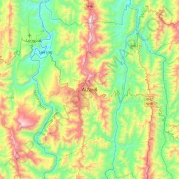
Name: Aizawl topographic map, elevation, terrain.
Location: Aizawl, Tlangnuam, Aizwal, Mizoram, 796190, India (23.58352 92.57829 23.90352 92.89829)
Average elevation: 556 m
Minimum elevation: 61 m
Maximum elevation: 1,509 m
Aizawl has a mild, sub-tropical climate due to its location and elevation. Under the Köppen climate classification, Aizawl features a humid subtropical climate (Cwa). In summer, temperatures are moderately warm, averaging around 20–30 °C (68–86 °F). In winter, daytime temperatures are cooler in comparison to the rest of the year, averaging around 11–21 °C (52–70 °F). Rainfall is mostly concentrated between April and October, with the heaviest rainfall occurring in May, July, August and September. The remainder of the year is notably drier.
Other topographic maps
Click on a map to view its topography, its elevation and its terrain.