
Dell City topographic map
Interactive map
Click on the map to display elevation.
About this map
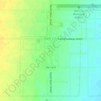
Name: Dell City topographic map, elevation, terrain.
Location: Dell City, Hudspeth County, Texas, United States (31.92353 -105.21094 31.94794 -105.18367)
Average elevation: 1,129 m
Minimum elevation: 1,118 m
Maximum elevation: 1,141 m
Other topographic maps
Click on a map to view its topography, its elevation and its terrain.
Sierra Blanca
United States > Texas > Hudspeth County
Sierra Blanca is found in Far West Texas, a subdivision of West Texas, and is 4,520 feet (1,380 m) above sea level. The town is part of the Trans-Pecos region within the most mountainous and arid portion of Texas. The town is located in Hudspeth County, which is large and sparsely populated. Sierra Blanca…
Average elevation: 1,391 m
Sierra Blanca
United States > Texas > Hudspeth County
Sierra Blanca is found in Far West Texas, a subdivision of West Texas, and is located at 31°10′55″N 105°20′27″W / 31.18194°N 105.34083°W / 31.18194; -105.34083 (31.182009, -105.340843) 4,520 feet (1,380 m) above sea level. The town is part of the Trans-Pecos region within the most…
Average elevation: 1,391 m