
Mata el Pendín topographic map
Interactive map
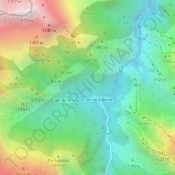
Click on the map to display elevation.
About this map
Name: Mata el Pendín topographic map, elevation, terrain.
Average elevation: 933 m
Minimum elevation: 419 m
Maximum elevation: 1,920 m
Other topographic maps
Click on a map to view its topography, its elevation and its terrain.
Caín de Valdeon
Spain > Castile and León > Posada de Valdeón
Caín de Valdeon, Posada de Valdeón, León, Castile and León, Spain
Average elevation: 1,088 m