
Thank you for supporting this site ❤️
Make a donation
Make a donation
Gear up for your next adventure:
As an Amazon Associate, this site earns from qualifying purchases at no extra cost to you.
Udaipurwati topographic map
Click on the map to display elevation.
Thank you for supporting this site ❤️
Make a donation
Make a donation
Gear up for your next adventure:
As an Amazon Associate, this site earns from qualifying purchases at no extra cost to you.
About this map
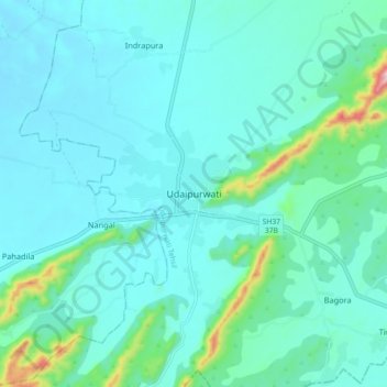
Name: Udaipurwati topographic map, elevation, terrain.
Location: Udaipurwati, Udaipurwati Tehsil, Jhunjhunun, Rajasthan, India (27.69099 75.43440 27.77099 75.51440)
Average elevation: 475 m
Minimum elevation: 428 m
Maximum elevation: 753 m
Thank you for supporting this site ❤️
Make a donation
Make a donation
Gear up for your next adventure:
As an Amazon Associate, this site earns from qualifying purchases at no extra cost to you.