
Fishers Island topographic map
Interactive map
Click on the map to display elevation.
About this map
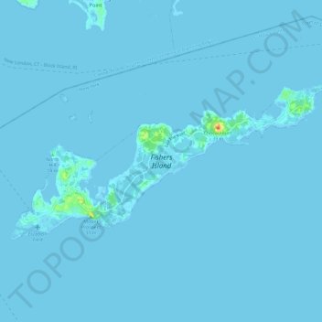
Name: Fishers Island topographic map, elevation, terrain.
Location: Fishers Island, Suffolk County, New York, United States (41.24944 -72.03866 41.29245 -71.92181)
Average elevation: 1 m
Minimum elevation: -2 m
Maximum elevation: 39 m
Other topographic maps
Click on a map to view its topography, its elevation and its terrain.
Battery Barlow (historical)
United States > New York > Suffolk County > Fishers Island > Fishers Island
Battery Barlow (historical), Fox Lane, Fishers Island, Suffolk County, New York, 06390, United States
Average elevation: 1 m