
Lake Of The Ozarks topographic map
Interactive map
Click on the map to display elevation.
Lake Of The Ozarks
The lake was created by the construction of the 2,543-foot (775 m) long Bagnell Dam by the Union Electric Company of St. Louis, Missouri. The principal engineering firm was Stone and Webster. Construction began August 8, 1929, was completed in April 1931 and reached spillway elevation on May 20, 1931. During construction, the lake was referred to as Osage Reservoir or Lake Osage. The Missouri General Assembly officially named it Lake Benton after Senator Thomas Hart Benton. None of the names stuck, as it was popularly referred to by its location at the northern edge of the Ozarks. The electric generating station, however, is still referred to by the utility company as the "Osage Hydroelectric Plant." While some sources indicate that more than 20 towns, villages and settlements were permanently flooded to create the lake, subsequent research indicates that the actual number was closer to eight, while several other sites had been previously abandoned, were relocated to make way for the lake, or were on high enough ground that the creation of the lake did not affect them.
About this map
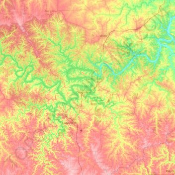
Name: Lake Of The Ozarks topographic map, elevation, terrain.
Average elevation: 265 m
Minimum elevation: 163 m
Maximum elevation: 381 m
Other topographic maps
Click on a map to view its topography, its elevation and its terrain.