
Thorn Hill topographic map
Interactive map
Click on the map to display elevation.
About this map
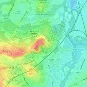
Name: Thorn Hill topographic map, elevation, terrain.
Average elevation: 82 m
Minimum elevation: 63 m
Maximum elevation: 118 m
Other topographic maps
Click on a map to view its topography, its elevation and its terrain.
Farnborough
United Kingdom > England > Hampshire > Rushmoor
Farnborough, Rushmoor, Hampshire, England, GU14 7JT, United Kingdom
Average elevation: 82 m
Aldershot
United Kingdom > England > Hampshire > Rushmoor
Aldershot, Rushmoor, Hampshire, England, GU11 1BX, United Kingdom
Average elevation: 92 m
Cargate Hill
United Kingdom > England > Hampshire > Rushmoor
Cargate Hill, Rushmoor, Hampshire, South East England, England, GU11 3AA, United Kingdom
Average elevation: 100 m
Normandy Barracks
United Kingdom > England > Hampshire > Rushmoor > Farnborough
Normandy Barracks, North Camp, Farnborough, Rushmoor, Hampshire, South East England, England, GU11 2LZ, United Kingdom
Average elevation: 76 m
The Crescent
United Kingdom > England > Hampshire > Rushmoor > Farnborough
The Crescent, Farnborough, Rushmoor, Hampshire, England, GU14 0FT, United Kingdom
Average elevation: 70 m