
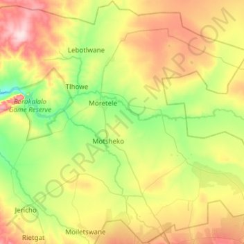
Moretele Local Municipality topographic map
Interactive map
Click on the map to display elevation.
About this map
Name: Moretele Local Municipality topographic map, elevation, terrain.
Average elevation: 1,057 m
Minimum elevation: 966 m
Maximum elevation: 1,211 m
Other topographic maps
Click on a map to view its topography, its elevation and its terrain.
Pilanesberg
South Africa > North West > Bojanala Platinum District Municipality > Moses Kotane Local Municipality
Average elevation: 1,489 m
Phokeng
South Africa > North West > Bojanala Platinum District Municipality > Rustenburg Local Municipality
Average elevation: 1,202 m
Kosmos
South Africa > North West > Bojanala Platinum District Municipality > Madibeng Local Municipality
Average elevation: 1,214 m