
Hunting Ridge topographic map
Interactive map
Click on the map to display elevation.
About this map
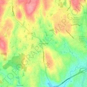
Name: Hunting Ridge topographic map, elevation, terrain.
Average elevation: 81 m
Minimum elevation: 28 m
Maximum elevation: 131 m
Other topographic maps
Click on a map to view its topography, its elevation and its terrain.
Belltown
United States > Connecticut > Western Connecticut Planning Region > Stamford
Belltown, Stamford, Western Connecticut Planning Region, Connecticut, 06906, United States
Average elevation: 32 m
Palmers Hill
United States > Connecticut > Western Connecticut Planning Region > Stamford
Palmers Hill, Stamford, Western Connecticut Planning Region, Connecticut, 06904, United States
Average elevation: 31 m
North Stamford
United States > Connecticut > Western Connecticut Planning Region > Stamford
North Stamford, Stamford, Western Connecticut Planning Region, Connecticut, 06903, United States
Average elevation: 89 m