
Stevensville topographic map
Interactive map
Click on the map to display elevation.
About this map
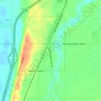
Name: Stevensville topographic map, elevation, terrain.
Average elevation: 193 m
Minimum elevation: 177 m
Maximum elevation: 215 m
Other topographic maps
Click on a map to view its topography, its elevation and its terrain.
Warren Dunes State Park
United States > Michigan > Berrien County > Bridgman
Warren Dunes State Park, 12032, Red Arrow Highway, Bridgman, Lake Charter Township, Berrien County, Michigan, 49125, United States
Average elevation: 191 m
Weko Beach
United States > Michigan > Berrien County > Bridgman
Weko Beach, Bridgman, Berrien County, Michigan, United States
Average elevation: 186 m
Grand Beach
United States > Michigan > Berrien County > New Buffalo Township
Grand Beach, New Buffalo Township, Berrien County, Michigan, United States
Average elevation: 183 m
Saint Joseph Charter Township
United States > Michigan > Berrien County
Saint Joseph Charter Township, Berrien County, Michigan, 49085, United States
Average elevation: 191 m
New Troy
United States > Michigan > Berrien County
New Troy, Weesaw Township, Berrien County, Michigan, 49119, United States
Average elevation: 198 m
Snow
United States > Michigan > Berrien County
Snow, Baroda Township, Berrien County, Michigan, 49101, United States
Average elevation: 199 m
Galien
United States > Michigan > Berrien County > Galien
Galien, Galien Township, Berrien County, Michigan, United States
Average elevation: 209 m
Dayton Lake
United States > Michigan > Berrien County > Dayton
Dayton Lake, Dayton, Bertrand Township, Berrien County, Michigan, United States
Average elevation: 226 m
Coloma
United States > Michigan > Berrien County > Coloma
Coloma, Berrien County, Michigan, United States
Average elevation: 200 m