
Stockertown topographic map
Interactive map
Click on the map to display elevation.
Stockertown
Belts of limestone lie under a part of the borough that borders Palmer Township and the nearby borough of Tatamy. This along with Hercules Cement's nearby quarrying makes these areas prone to sinkholes (see Karst Topography), and led to the closure of a bridge that carried a state road (Bushkill Street) over the Bushkill Creek. This bridge remains closed as of 2018.
About this map
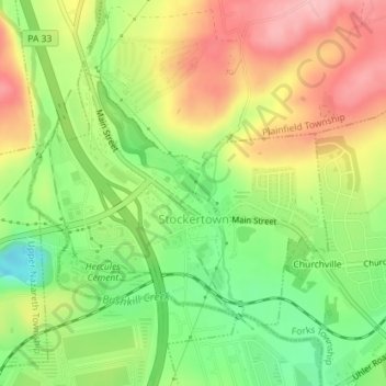
Name: Stockertown topographic map, elevation, terrain.
Average elevation: 132 m
Minimum elevation: 64 m
Maximum elevation: 203 m
Other topographic maps
Click on a map to view its topography, its elevation and its terrain.
Portlamd Waterfront Park
United States > Pennsylvania > Northampton County > Portland
Average elevation: 118 m
Moorestown
United States > Pennsylvania > Northampton County > Moore Township
Average elevation: 219 m
Martins Creek
United States > Pennsylvania > Northampton County > Lower Mount Bethel Township
Average elevation: 127 m
West Bangor
United States > Pennsylvania > Northampton County > Washington Township
Average elevation: 310 m
Mount Bethel
United States > Pennsylvania > Northampton County > Upper Mount Bethel Township
Average elevation: 156 m
Mount Bethel
United States > Pennsylvania > Northampton County > Upper Mount Bethel Township
Average elevation: 156 m
Brodhead
United States > Pennsylvania > Northampton County > Bethlehem Township
Average elevation: 115 m
Northwood Heights
United States > Pennsylvania > Northampton County > Palmer Township > Palmer Heights
Average elevation: 110 m