
Squaw Valley topographic map
Interactive map
Click on the map to display elevation.
About this map
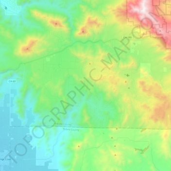
Name: Squaw Valley topographic map, elevation, terrain.
Average elevation: 557 m
Minimum elevation: 128 m
Maximum elevation: 1,621 m
Squaw Valley (formerly, Squawvalley) is a census-designated place located in Fresno County, California, in the United States. As of the 2010 census, the CDP had a total population of 3,162, up from 2,691 at the 2000 census. Despite the similar name, it is not the location of Squaw Valley Ski Resort or the 1960 Winter Olympics. Squaw Valley is located 9 miles (14 km) north-northeast of Orange Cove and 30 miles (48 km) east of Fresno, at an elevation of 1,631 ft (497 m).