
Barnstead topographic map
Interactive map
Click on the map to display elevation.
Barnstead
Barnstead is a town in Belknap County, New Hampshire, United States. The population was 4,593 at the 2010 census. Home to the Suncook Lakes, Barnstead includes the villages of Center Barnstead, Barnstead Parade (identified as "Barnstead" on topographic maps) and South Barnstead.
About this map
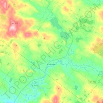
Name: Barnstead topographic map, elevation, terrain.
Location: Barnstead, Belknap County, New Hampshire, United States (43.28444 -71.34881 43.41836 -71.15894)
Average elevation: 221 m
Minimum elevation: 116 m
Maximum elevation: 422 m
Other topographic maps
Click on a map to view its topography, its elevation and its terrain.