Geolocate

Versailles topographic map

Interactive map

Click on the map to display elevation.

About this map

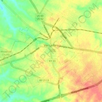
Name: Versailles topographic map, elevation, terrain.

Location: Versailles, Woodford County, Kentucky, 40383, United States (38.02619 -84.76999 38.07285 -84.70022)

Average elevation: 275 m

Minimum elevation: 242 m

Maximum elevation: 305 m

Other topographic maps

Click on a map to view its topography, its elevation and its terrain.

Midway

United States > Kentucky > Woodford County

Midway, Woodford County, Kentucky, United States

Average elevation: 256 m

Woodford County

United States > Kentucky > Woodford County

Woodford County, Kentucky, United States

Average elevation: 259 m