
Bryce topographic map
Interactive map
Click on the map to display elevation.
About this map
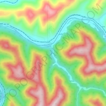
Name: Bryce topographic map, elevation, terrain.
Location: Bryce, Fayette County, West Virginia, 26656, United States (38.20316 -81.17177 38.24316 -81.13177)
Average elevation: 379 m
Minimum elevation: 191 m
Maximum elevation: 598 m
Other topographic maps
Click on a map to view its topography, its elevation and its terrain.
New River Gorge National Park and Preserve
United States > West Virginia > Fayette County > Oak Hill
Average elevation: 694 m