
Guilford topographic map
Interactive map
Click on the map to display elevation.
About this map
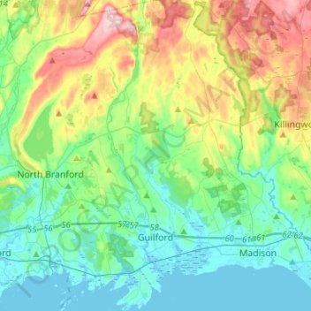
Name: Guilford topographic map, elevation, terrain.
Average elevation: 62 m
Minimum elevation: -3 m
Maximum elevation: 219 m
Other topographic maps
Click on a map to view its topography, its elevation and its terrain.
Big Indian
United States > Connecticut > South Central Connecticut Planning Region > Guilford
Average elevation: 41 m
East River
United States > Connecticut > South Central Connecticut Planning Region > Madison
Average elevation: 9 m
Forest Heights
United States > Connecticut > South Central Connecticut Planning Region > Milford
Average elevation: 19 m
Fort Trumbull
United States > Connecticut > South Central Connecticut Planning Region > Milford
Average elevation: 7 m
Brightview
United States > Connecticut > South Central Connecticut Planning Region > New Haven
Average elevation: 5 m
Morningside
United States > Connecticut > South Central Connecticut Planning Region > Milford
Average elevation: 5 m
Mount Carmel Center
United States > Connecticut > South Central Connecticut Planning Region > Hamden
Average elevation: 79 m
Bayview
United States > Connecticut > South Central Connecticut Planning Region > Milford
Average elevation: 5 m
South Meriden
United States > Connecticut > South Central Connecticut Planning Region > Meriden
Average elevation: 55 m
Momauguin
United States > Connecticut > South Central Connecticut Planning Region > East Haven
Average elevation: 3 m
Quinnipiac
United States > Connecticut > South Central Connecticut Planning Region > Wallingford
Average elevation: 31 m
Ansonia
United States > Connecticut > South Central Connecticut Planning Region
Average elevation: 111 m
Lake Whitney
United States > Connecticut > South Central Connecticut Planning Region > Hamden
Average elevation: 25 m
North Branford Town Green
United States > Connecticut > South Central Connecticut Planning Region > North Branford
Average elevation: 44 m