
Remich topographic map
Interactive map
Click on the map to display elevation.
About this map
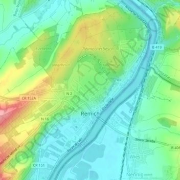
Name: Remich topographic map, elevation, terrain.
Location: Remich, Canton Remich, Luxembourg (49.53424 6.33917 49.56146 6.38177)
Average elevation: 172 m
Minimum elevation: 137 m
Maximum elevation: 250 m
Other topographic maps
Click on a map to view its topography, its elevation and its terrain.
Greiveldange
Luxembourg > Canton Remich > Greiveldange
Greiveldange, Stadtbredimus, Canton Remich, 5426, Luxembourg
Average elevation: 211 m
Ellange Gare
Luxembourg > Canton Remich > Ellange > Ellange Gare
Ellange Gare, Ellange, Mondorf-les-Bains, Canton Remich, 5691, Luxembourg
Average elevation: 242 m
Ellange
Luxembourg > Canton Remich > Ellange
Ellange, Mondorf-les-Bains, Canton Remich, 5690, Luxembourg
Average elevation: 246 m