
Riddle topographic map
Interactive map
Click on the map to display elevation.
About this map
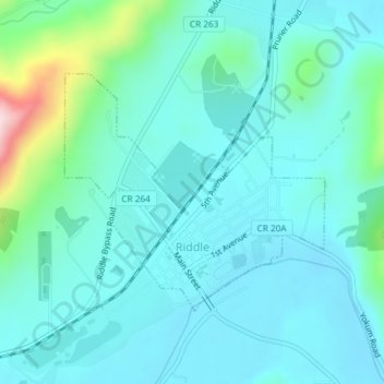
Name: Riddle topographic map, elevation, terrain.
Location: Riddle, Douglas County, Oregon, United States of America (42.94641 -123.37653 42.96311 -123.35149)
Average elevation: 246 m
Minimum elevation: 195 m
Maximum elevation: 504 m
Riddle is about 25 miles (40 km) south of Roseburg and 220 miles (350 km) south of Portland. It lies about 4 miles (6.4 km) west of Oregon Route 99 (Interstate 5) at an elevation of about 700 feet (210 m) above sea level. Cow Creek flows by Riddle before entering the nearby South Umpqua River.