
Earl Bales Park topographic map
Interactive map
Click on the map to display elevation.
About this map
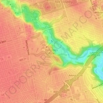
Name: Earl Bales Park topographic map, elevation, terrain.
Average elevation: 177 m
Minimum elevation: 131 m
Maximum elevation: 193 m
Other topographic maps
Click on a map to view its topography, its elevation and its terrain.
Toronto
Despite its deep ravines, Toronto is not remarkably hilly, but its elevation does increase steadily away from the lake. Elevation differences range from 76.5 metres (251 ft) above sea level at the Lake Ontario shore to 209 m (686 ft) ASL near the York University grounds in the city's north end at the…
Average elevation: 113 m