
Tarifa topographic map
Interactive map
Click on the map to display elevation.
About this map
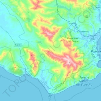
Name: Tarifa topographic map, elevation, terrain.
Location: Tarifa, Campo de Gibraltar, Cádiz, Andalusia, 11380, Spain (36.00004 -5.84219 36.26499 -5.49504)
Average elevation: 141 m
Minimum elevation: -3 m
Maximum elevation: 819 m
Other topographic maps
Click on a map to view its topography, its elevation and its terrain.
Castillo de Castellar
Spain > Andalusia > Campo de Gibraltar > Castellar de la Frontera > Castellar Viejo de la Frontera
Average elevation: 102 m