
Kabul District topographic map
Interactive map
Click on the map to display elevation.
About this map
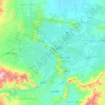
Name: Kabul District topographic map, elevation, terrain.
Location: Kabul District, Kabul Province, Afghanistan (34.40702 68.99655 34.61048 69.36164)
Average elevation: 1,968 m
Minimum elevation: 1,729 m
Maximum elevation: 3,195 m
Other topographic maps
Click on a map to view its topography, its elevation and its terrain.
Bagrami
Afghanistan > Kabul Province > Bagrami District
Bagrami, Bagrami District, Kabul Province, Afghanistan
Average elevation: 1,801 m
Kabul
Afghanistan > Kabul Province > Kabul District
Kabul, Kabul District, Kabul Province, 1001, Afghanistan
Average elevation: 1,945 m
Paghman
Afghanistan > Kabul Province > Paghman
Paghman, Kabul Province, Afghanistan
Average elevation: 2,606 m
Surobi
Afghanistan > Kabul Province > Surobi > Surobi
Surobi, Kabul Province, Afghanistan
Average elevation: 1,520 m
Chashmah-ye Masti
Afghanistan > Kabul Province > Surobi > Chashmah-ye Masti
Chashmah-ye Masti, Surobi, Kabul Province, Afghanistan
Average elevation: 1,425 m
Shakardara
Shakardara, Kabul Province, 1061, Afghanistan
Average elevation: 2,281 m