
Lake Çıldır topographic map
Interactive map
Click on the map to display elevation.
About this map
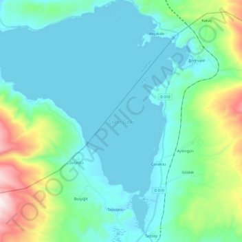
Name: Lake Çıldır topographic map, elevation, terrain.
Average elevation: 2,116 m
Minimum elevation: 1,957 m
Maximum elevation: 2,825 m
Lake Çıldır (Turkish: Çıldır Gölü, Armenian: Ծովակ լիճ Tsovak lič, Georgian: ჩრდილი, ჩრდილის ტბა Črdilis tba, meaning "lake of shadows"), is a large freshwater lake in the Ardahan Province, northeastern part of Turkey. It is located at 41°02′33″N 43°15′19″E / 41.0425°N 43.2552778°E / 41.0425; 43.2552778, close to the borders with Georgia and Armenia. Lake Çıldır is located at the elevation of about 1,900 m (6,200 ft) and is surrounded by a mountainous region. It has an area of 123.00 km2 (47.49 sq mi) and a maximum depth of about 42 m (138 ft). Water from the lake is used for irrigation.