
Warsaw topographic map
Interactive map
Click on the map to display elevation.
About this map
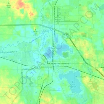
Name: Warsaw topographic map, elevation, terrain.
Location: Warsaw, Kosciusko County, Indiana, 46580, United States (41.20487 -85.89126 41.29028 -85.78231)
Average elevation: 256 m
Minimum elevation: 243 m
Maximum elevation: 281 m
Other topographic maps
Click on a map to view its topography, its elevation and its terrain.
Leesburg
United States > Indiana > Kosciusko County
Leesburg, Kosciusko County, Indiana, United States
Average elevation: 261 m
Warsaw
United States > Indiana > Kosciusko County > Warsaw > Warsaw
Warsaw, Kosciusko County, Indiana, 4650, United States
Average elevation: 255 m