
Albert Luthuli Local Municipality topographic map
Interactive map
Click on the map to display elevation.
About this map
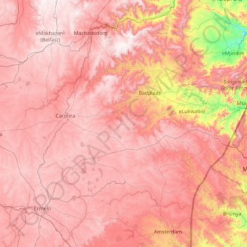
Name: Albert Luthuli Local Municipality topographic map, elevation, terrain.
Average elevation: 1,504 m
Minimum elevation: 578 m
Maximum elevation: 2,030 m
Other topographic maps
Click on a map to view its topography, its elevation and its terrain.
Volksrust
South Africa > Mpumalanga > Gert Sibande > Pixley Ka Seme Local Municipality
The town was laid out in 1888 on the farms Boschpad Drift, Rooibult or Llanwarne, Verkyk and Zandfontein, and proclaimed in 1889. It lies at an elevation of 5,429 feet (1,655 m), and 4 miles (6.4 km) north of the pass through the Drakensberg known as Laing's Nek. Municipal status was attained in 1904.
Average elevation: 1,688 m
Amsterdam
South Africa > Mpumalanga > Gert Sibande > Mkhondo Local Municipality
Average elevation: 1,290 m
Mpuluzi
South Africa > Mpumalanga > Gert Sibande > Albert Luthuli Local Municipality
Average elevation: 1,458 m
Carolina
South Africa > Mpumalanga > Gert Sibande > Albert Luthuli Local Municipality
Average elevation: 1,675 m
eLukwatini
South Africa > Mpumalanga > Gert Sibande > Albert Luthuli Local Municipality
Average elevation: 1,033 m
Vygeboom Dam
South Africa > Mpumalanga > Gert Sibande > Albert Luthuli Local Municipality
Average elevation: 1,056 m
Thuthukani
South Africa > Mpumalanga > Gert Sibande > Lekwa Local Municipality
Average elevation: 1,586 m
Standerton
South Africa > Mpumalanga > Gert Sibande > Lekwa Local Municipality
Average elevation: 1,554 m
Blesbokspruit
South Africa > Mpumalanga > Gert Sibande > Lekwa Local Municipality
Average elevation: 1,606 m
Piet Retief
South Africa > Mpumalanga > Gert Sibande > Mkhondo Local Municipality
Average elevation: 1,276 m
Standerton
South Africa > Mpumalanga > Gert Sibande > Lekwa Local Municipality
Average elevation: 1,554 m
Volksrust
South Africa > Mpumalanga > Gert Sibande > Pixley Ka Seme Local Municipality
The town was laid out in 1888 on the farms Boschpad Drift, Rooibult or Llanwarne, Verkyk and Zandfontein, and proclaimed in 1889. It lies at an elevation of 5,429 feet (1,655 m), and 4 miles (6.4 km) north of the pass through the Drakensberg known as Laing's Nek. Municipal status was attained in 1904.
Average elevation: 1,688 m
eLukwatini
South Africa > Mpumalanga > Gert Sibande > Albert Luthuli Local Municipality
Average elevation: 1,033 m
Evander
South Africa > Mpumalanga > Gert Sibande > Govan Mbeki Local Municipality
Average elevation: 1,628 m
Amersfoort
South Africa > Mpumalanga > Gert Sibande > Pixley Ka Seme Local Municipality
Average elevation: 1,660 m
Balfour
South Africa > Mpumalanga > Gert Sibande > Dipaleseng Local Municipality
Average elevation: 1,636 m
Volksrust
South Africa > Mpumalanga > Gert Sibande > Pixley Ka Seme Local Municipality
The town was laid out in 1888 on the farms Boschpad Drift, Rooibult or Llanwarne, Verkyk and Zandfontein, and proclaimed in 1889. It lies at an elevation of 5,429 feet (1,655 m), and 4 miles (6.4 km) north of the pass through the Drakensberg known as Laing's Nek. Municipal status was attained in 1904.
Average elevation: 1,688 m