
Mt. Unzen topographic map
Interactive map
Click on the map to display elevation.
About this map
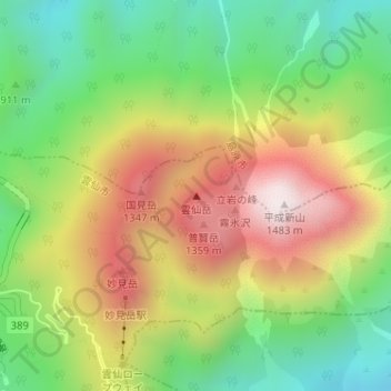
Name: Mt. Unzen topographic map, elevation, terrain.
Location: Mt. Unzen, Unzen, Nagasaki Prefecture, 859-1501, Japan (32.76185 130.29160 32.76195 130.29170)
Average elevation: 985 m
Minimum elevation: 605 m
Maximum elevation: 1,457 m
Other topographic maps
Click on a map to view its topography, its elevation and its terrain.